Monitoring Stream Turbidity, Erosion and Sedimentation
Erosion is a natural process that has been occurring in the Catawba River basin since the river first formed. However, human activity can greatly accelerate erosion. Sediment, produced by erosion, is the number one source of pollution in North Carolina waterways. Sources of sediment include: construction site activities, farmland erosion, streambank erosion and alterations, and the removal of well-forested buffers along streams. Excessive sediment in the water buries aquatic nurseries, reduces water clarity and suffocates fish. Sediment can also carry harmful pollutants such as fertilizers and pesticides, pathogens, fecal matter, and heavy metals that further hinder the aquatic conditions for fish and other wildlife within the ecosystem.
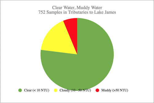
LJEA has been monitoring the amount of sediment, and the turbidity (cloudiness) of the water, at a limited number of sites in our streams since 2002. That monitoring has indicated that we have levels of sediment and turbidity that are similar to streams across western North Carolina. Beginning in March 2016, LJEA expanded its monitoring efforts and has recorded 735 turbidity observations. Approximately 76% of samples were “clear,” 18% had enough sediment so that they were not healthy over the long term for sensitive species (such as trout) and 6% of the samples were turbid and unhealthy for most aquatic species if they were exposed to that level over a long period. An important source of sediment is streambank erosion. In 2018, LJEA and Appalachian State University assessed 21 stream reaches for erosion potential. Ten of the reaches had low erosion potential and eleven had moderate erosion potential, two sites being ranked just below a high erosion hazard index. This work continues and future work will include assessing upland erosion and Lake James shore erosion.
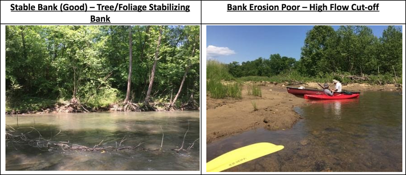
LJEA’s Citizen Science Committee has been studying erosion and the transport of sediment in our streams. Since a major source of sediment is streambank erosion, the committee plans to continue its efforts to identify areas of severe bank erosion in the watershed. In May of 2019, several LJEA members paddled the Catawba from Parker Padgett Road (this is downstream of Old Fort) to the Greenway North Main access in Marion. This stretch of river was in good shape from a bank erosion viewpoint. We visually surveyed the entire section of the river and stopped at 15 locations to quantify bank erosion on each side of the river, document bank organic cover, water turbidity, condition of the riparian buffer, and to take pictures. 77% of our observations graded the banks to be in “good – fair” condition and the balance was “fair – poor”. Examples of “good” and “poor” bank erosion conditions are shown in the pictures below.
LJEA plans to complete the Catawba assessment from the Greenway to the Lake and an assessment of part of the Crooked Creek watershed in 2020.
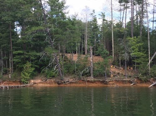
The Lake James shoreline has been eroding since the lake was formed. LJEA monitors the clarity of the water in Lake James monthly at five different locations for seven months of each year. There is little data available to quantify the erosion rates and whether those rates are accelerating. There are, however, some factors that indicate that shoreline erosion may be increasing, including continuing shoreline development and the increase in boat traffic on the lake. Both shoreline erosion and sediment delivered to the lake by the inflowing rivers and streams are contributing to the accumulation of sediment on the lake bottom.
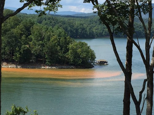
From the perspective of water supply and hydropower production, given the large volume of water stored in the lake, the amount of sediment that has accumulated is of little concern. However, the accumulated sediment has impacted the aquatic habitat and fisheries in the lake and sometimes presents problems for boating and docks in parts of the lake. The turbidity of the lake water is sometimes a concern to those who boat, fish and swim in the lake. Shoreline erosion rates around Lake James likely exceed those in most western North Carolina lakes. The primary factors causing higher erosion rates, beyond natural conditions, are the high volume of boat traffic and the way that the lake is operated. Even under average rainfall conditions, the water level in Lake James is seasonally varied nearly ten feet, much more than most western NC lakes. That variation exposes the shoreline to erosion and makes it very difficult to establish vegetation within that zone.
Each year, LJEA members put in hundreds of hours of volunteer time, pay for equipment, supplies, laboratory expenses, and drive their cars and boats many hundreds of miles to monitor our streams and the lake. Their commitment to the protection, preservation, and restoration of the Lake James watershed is an investment in the future of our community. If you are interested in joining our team of volunteers and helping collect this important data, please visit our Volunteer with LJEA page.